
For updated information about Church maps, see “Maps for Stakes, Wards, and Missions.”
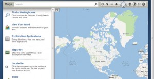
LDS Maps (maps.lds.org or go to LDS.org, click Tools, then Maps) has been updated with a variety of new features to make it easier to find stake members, meetinghouses, temples, and other Church facilities. Some of the new features include a number of map display options, better iPad and tablet support, unit boundary maps, the Locate Me feature, and improved print options. You can view and print driving directions and share map links through social media. LDS Maps replaces the old Meetinghouse Locator.
Here are two great new features you should look at:
Ward/Stake Map
After you sign in with your LDS Account, click View Your Ward and you will see a map of the members of your ward. The sidebar will show a list of member names. In addition to looking up where members live, you could use it for
Emergency preparedness planningDividing up the ward for distributing fliersPlanning routes for collecting fast offeringsHome and visiting teachingMissionary workRealignment of ward boundaries in the stake
Find Other Church Buildings
In the upper right, click the Layers icon to search for temples, visitors’ centers, historical places, tabernacles, institutes, seminaries, bishops’ storehouses, canneries, home storage centers, Deseret Industries, Employment Resource Centers, and LDS Family Services offices.
I would like to inquire who is in charge of the building maintenance like repainting termite control etc in Brisbane Australia. Your help will be highly appreciated.
Brother Francis Saludo